Setp 1 : Carefully Plan the Foundation Excavation
Before beginning the excavation, meticulous planning is essential. Depending on the location, the terrain’s topography and the municipal regulations the projet may change. We use the GPS to accurately mark the dimensions and location of the future foundation.
Step 2 : Start the excavation
Begin with the initial excavation, following the GPS markers based on a digitized plan. Use suitable tools to efficiently dig the soil according to the pre-established dimensions.
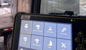
Step 3 : Follow the GPS Throughout the Excavation
Throughout the process, the GPS will help maintain precision and ensure that you adhere to the dimensions and depths of the excavation. This step ensures the stability of the final structure and ensures the foundations are reviewed with perfection.
Step 4 : Consolidation and Finishing Touches
Once the excavation is complete, we reinforce the walls and ceiling to ensure the foundation’s strength. We add the necessary finishing touches to make the foundation functional.
Thanks to meticulous planning and the judicious use of GPS technology, excavating foundations alone is now possible! At Vallex Excavation, we provide all the necessary tools to successfully complete your excavation project, while ensuring the solidity and precision required for a reliable foundation.